
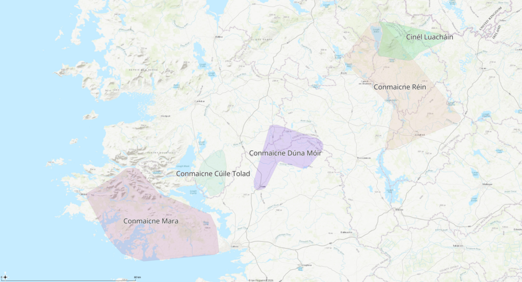
The Early History of the Conmaicne
The Conmaicne were among the most widely dispersed and historically important population groups of early Connacht. Their name survived in several regional territories extending from the Atlantic coast of Connemara through central Galway and north Roscommon to Longford, southern Leitrim and the upper Shannon. Yet they never developed into a single durable provincial dynasty comparable to the Uí Conchobair, Uí Briúin Bréifne or Uí Fiachrach. Instead, the Conmaicne appear in the historical record as a collection of related peoples whose separate kingdoms were gradually absorbed into larger political systems. Their secular power diminished, but their territorial identities, churches, learned families and local communities continued to shape the medieval landscape long after independent Conmaicne kingship had disappeared.
The name Conmaicne was conventionally understood to mean the descendants of Conmac, who was presented in medieval genealogy as a son of Fergus mac Róich, the celebrated Ulster hero associated with the Táin Bó Cúailnge. The genealogical tradition made Conmac the ancestor of several branches, including the Conmaicne Mara, Conmaicne Dúna Móir, Conmaicne Cúile Tolad, Conmaicne Réin and Conmaicne Bec. The Book of Fenagh preserves this descent and treats the different Conmaicne territories as branches of one ancestral population.
This ancestry should not be accepted as literal history without qualification. Fergus mac Róich belongs primarily to the world of heroic literature, while the pedigrees connecting early peoples to famous ancestral figures were written down centuries after the societies they purported to describe. Medieval genealogists commonly converted political association, territorial relationship, shared cults and ecclesiastical obligations into father-to-son descent. The claim that all Conmaicne descended biologically from one historical Conmac may therefore represent a learned attempt to explain the similarity of their names and their remembered relationship.
The repeated appearance of the Conmaicne name across western and central Ireland nevertheless indicates something real. The different branches were not randomly named. They probably preserved the memory of an older population grouping that had once possessed a wider political or cultural coherence. This may have arisen through common descent, migration, political confederation, shared cult affiliation or some combination of these. What can be said securely is that, by the period in which Ireland’s early territorial geography becomes visible, several communities identifying as Conmaicne occupied a broad arc across Connacht and the northern midlands.
These territories were separated from one another by other peoples and later dynasties. The Conmaicne were therefore not a single compact kingdom. Their distribution resembles the remains of an older population layer that had been divided by later expansion. This pattern is common in early Irish history. Powerful dynasties expanded across existing communities, appropriated their principal royal sites and incorporated surviving local rulers into new genealogies. Older peoples might disappear from the annals as political actors while remaining numerous on the land.
The most westerly branch was the Conmaicne Mara, whose name survives in Connemara. Their territory occupied much of western County Galway between Lough Corrib and the Atlantic. The word mara, meaning “of the sea,” distinguished this coastal branch from the inland Conmaicne. Their landscape included mountain valleys, islands, Atlantic inlets, lakes and difficult upland routes. Such terrain did not favour the development of one heavily centralised kingship, but it allowed local communities to preserve a strong identity despite the pressure of larger neighbouring dynasties.
The Conmaicne Mara were eventually overshadowed by the Uí Briúin Seóla and, later, by the Ó Flaithbheartaigh dynasty. The political transfer was gradual. It should not be imagined as the removal of one population and its replacement by another. The more likely process involved the extension of a new ruling genealogy over existing communities. Local Conmaicne families remained in place while their rulers became dependants, clients or subordinate branches of the emerging Uí Briúin order. By the later Middle Ages, the region was known principally through the Ó Flaithbheartaigh lordship, but the ancient Conmaicne name remained fixed in Connemara itself.
East of Lough Corrib lay the Conmaicne Cúile Tolad. Their territory is generally associated with the district later called Kilmaine in southern County Mayo and adjoining parts of Galway. The territorial name probably referred to a particular plain or corner of land rather than to the entire modern region. This branch occupied a strategically important zone between the Lough Corrib basin, the plains of south Mayo and the approaches to central Connacht.
The Conmaicne Cúile Tolad were exposed to pressure from several directions. To the west lay the Conmaicne Mara; to the north and northeast were Uí Fiachrach and other Mayo powers; to the east were expanding Uí Briúin groups; and to the south were territories that eventually fell within the orbit of Tuam. This position helps explain why the branch remained identifiable but did not create a major overkingdom. Its communities were incorporated into larger ecclesiastical and dynastic structures while preserving a regional name.
Farther east lay the Conmaicne Dúna Móir, also known as Conmaicne Cenóil Dubáin. Their territory centred on Dunmore in north County Galway and extended into adjoining portions of Roscommon. It included much of the later barony of Dunmore and part of Ballymoe. The region lay along an important transitional belt between the central Connacht plain, the river Suck basin and the approaches to Tuam.
The Conmaicne Dúna Móir were still a recognisable political people in the eighth century. Their defeat near Shrule in 766 marked a major stage in the expansion of the Uí Briúin into their territory. Eamonn Kelly’s reconstruction of the wider Dunmore landscape places the Conmaicne Dúna Móir within an extensive borderland later dominated by Uí Briúin Aí and the Uí Conchobair kings. The battle should not necessarily be interpreted as the instant extinction of their rulers. It more probably marked the loss of political independence and the beginning of their subordination to a stronger dynasty.
The location was exceptionally important. Tuam lay near the southwestern edge of the territory and eventually became both a principal Uí Conchobair centre and the metropolitan church of Connacht. Control of the district therefore meant more than possession of farmland. It provided access to ecclesiastical authority, regional roads, river valleys, grazing lands and the political heart of central Connacht. The absorption of Conmaicne Dúna Móir into the Uí Briúin world helped create the territorial base from which the Uí Conchobair later dominated Connacht.
The Conmaicne were also connected to a landscape of royal hunting, assembly and inherited mythology. The upland region extending between Lough O’Flynn, Slieve O’Flynn, Kiltullagh, Kilkeevin, Templetogher and Dunmore appears in medieval literature as a formáel, a wild or marginal landscape associated with hunting, conflict and the Fianna. This zone crossed several political territories, including Conmaicne Dúna Móir. Its scale suggests that early boundaries were not simply lines on a map. They were broad landscapes in which rulers hunted, gathered followers, displayed authority and negotiated access to woodland, pasture and water.
The largest and most consequential eastern branch was Conmaicne Réin. Their territory extended through much of modern County Longford and southern County Leitrim. It was preserved most clearly in the medieval diocese of Ardagh, whose boundaries retained the outline of the older Conmaicne political world after secular control had changed. Paul MacCotter identifies Conmaicne Réin as occupying much of Longford and southern Leitrim, with their ecclesiastical geography surviving in the territory of Ardagh diocese.
The element Réin referred to Mag Réin, the plain or regional territory associated particularly with southern Leitrim. This was not an isolated district. It lay along the upper Shannon and its tributaries, connected northward toward Lough Allen and Bréifne, southward toward the midlands, westward toward north Roscommon and Moylurg, and eastward through Longford. The region formed part of a wider inland world of lakes, rivers, drumlin passages and lowland corridors. Such geography allowed movement while also creating defensible local districts. The importance of this linked landscape is increasingly recognised in studies of long-term settlement within the upper Shannon and Erne sphere.
Conmaicne Réin was probably not ruled permanently from a single capital. Like many early Irish peoples, it was divided into smaller kingdoms, local lordships and ecclesiastical communities. The later territorial divisions of Muintir Eolais, Muintir Anghaile and related districts may preserve the fragmentation of the older Conmaicne world. By the high Middle Ages, Ó Fearghail rulers dominated much of Longford, while Muintir Eolais controlled an important area in southern Leitrim. These later dynasties inherited territories that had previously formed part of the broader Conmaicne Réin sphere.
The relationship between Conmaicne Réin and Muintir Eolais is especially important. The latter territory included portions of southern Leitrim and at an earlier period extended westward into north Roscommon. Kilronan parish, although now geographically associated with the Boyle region, remained within the diocese of Ardagh rather than Elphin. This ecclesiastical anomaly preserves its older affiliation with the Conmaicne and Muintir Eolais world. Kelly notes that the older territory, Tír Tuathail, extended toward Lough Key and that the Roscommon lands adjoining Kilmactranny had originally belonged to Muintir Eolais under Conmaicne Réin control.
This suggests that the early Conmaicne sphere reached farther west than the later county boundary between Leitrim and Roscommon. Its communities were connected with the Lough Key basin, the eastern Sligo borderlands and the routes leading toward Moytura and Lough Arrow. These connections do not prove that the entire region from Longford to Sligo formed one united kingdom. They do show that later diocesan, baronial and county divisions concealed an older pattern of population and ecclesiastical relationships.
North of the main Conmaicne Réin territory lay Cenél Luacháin. This people occupied the Ballinamore, Oughteragh and Drumreilly district in southern and central Leitrim, extending into adjoining Cavan. MacCotter identifies Cenél Luacháin as a branch of Conmaicne Réin and argues that their territory was probably detached from the wider Conmaicne region by the expansion of Uí Briúin Bréifne. Their lands linked otherwise separate portions of the developing Bréifne overkingdom, making political reorganisation likely.
This is a significant reconstruction. It implies that the rise of Bréifne divided an earlier Conmaicne landscape rather than simply conquering a completely foreign territory. Cenél Luacháin became enclosed within the new Bréifne system while the main body of Conmaicne Réin remained to the south. Its people were increasingly associated with the Uí Ruairc kingdom and later with the diocese of Kilmore, although their older Conmaicne identity survived in genealogy and church tradition.
The early history of Bréifne demonstrates how such a division could have occurred. In the seventh century, the later Uí Briúin Bréifne kingdom was not yet visible in the Patrician material. The region was occupied by several older peoples, including the Masraige, Cechtraige, Gailenga, Saithne, Callraige, Dartraige, Conmaicne Réin and Cenél Luacháin. Reliable annalistic references to Bréifne kings begin only near the end of the eighth century, while the ruling line that produced the Uí Ruairc becomes firmly visible from the late ninth century.
The expansion of Bréifne therefore belongs to a period of major territorial reconstruction. Later genealogies portrayed its ruling family as an established branch of Uí Briúin Connacht, but scholars have questioned whether this descent was entirely genuine. It may have been partly created to justify Bréifne claims to the kingship of Connacht. Regardless of the dynasty’s ultimate origin, its rise brought several older communities under one overkingdom. The Conmaicne did not disappear immediately, but their territories were divided and their rulers subordinated.
Christianity provided the Conmaicne with a different form of continuity. Their political identity weakened, yet churches founded within their territories preserved local memory, burial rights and claims to land. The saint most closely associated with Conmaicne Réin was Caillín of Fenagh. Later tradition presented Caillín himself as belonging to the Conmaicne, possibly to the Dún Mór branch, while locating his greatest foundation at Fenagh among Conmaicne Réin. He was also credited with a church among Conmaicne Mara at Slyne Head, giving his cult an extraordinary geographical range across the separate branches.
The historical Caillín is difficult to recover beneath the later literature. The surviving Book of Fenagh was compiled and revised long after the supposed lifetime of the saint. Its accounts of royal grants, curses, tributes and prophecies cannot be read as contemporary records of the sixth century. Nevertheless, the text preserves the institutional claims of Fenagh and the manner in which its community understood the Conmaicne past.
Fenagh was portrayed as the burial place of the Conmaicne, their place of reconciliation and the sacred centre to which their different territories owed tribute. The Book of Fenagh states that the Conmaicne were bound to Caillín through cattle dues, offerings, military symbols and burial obligations. It also describes periods in which they abandoned the saint, were censured and were eventually restored to his protection. These stories are religious literature, but they encode political relationships. They transformed Fenagh’s rights over land and people into commands supposedly issued in the age of saints.
Fenagh’s importance may have increased precisely because Conmaicne secular unity was breaking down. A church could preserve the memory of a people after that people had lost its independent kingship. Rulers who conquered Conmaicne territories might still recognise Fenagh’s burial status, relics, sanctuary and inherited dues. The church therefore became the institutional heir of the older political order.
Caillín’s traditions also linked the different Conmaicne branches. Whether these links reflected the journeys of one historical missionary or the later expansion of his cult is uncertain. A church seeking authority over dispersed communities had an incentive to portray their common ancestor and common saint as belonging to one sacred history. Even so, the geographical breadth of the tradition suggests that real contact existed among Conmaicne church communities.
Other saints and churches complicate the picture. Early Connacht Christianity did not follow later diocesan boundaries. Foundations associated with Patrick, Colum Cille and regional saints crossed the territories of Conmaicne, Callraige, Uí Fiachrach and Uí Briúin. Drumlease, for example, lay among the Callraige Trí Maige in north Leitrim but was connected to a wider Patrician network. The Book of Armagh preserves material showing Drumlease as a significant church in the later seventh and eighth centuries and associates its foundation with the baptism of the local population.
The importance of Drumlease helps explain why the boundary between the Conmaicne, Callraige and later Bréifne worlds should not be treated as rigid. Church families, dependent settlements and inherited estates could cross secular divisions. A community might become politically subject to a new king while retaining the cult, property and clergy of an older regional federation.
By the eleventh century, the Conmaicne no longer appear as a unified secular power. Conmaicne Mara had fallen within the expanding western Uí Briúin world. Conmaicne Dúna Móir had been absorbed into the central Connacht kingdom dominated by Uí Briúin Aí and Uí Conchobair. Conmaicne Réin had been divided among emerging dynasties in Longford and Leitrim, while Cenél Luacháin had been incorporated into Bréifne. Yet the name continued to carry meaning because the underlying population remained.
This distinction between political disappearance and demographic survival is essential. Medieval conquests rarely involved the replacement of entire populations. Ordinary Conmaicne households continued to cultivate land, raise cattle, serve churches, enter fosterage relationships, supply warriors and marry into neighbouring communities. Their descendants acquired the surnames of local ruling or professional families. Others became members of territorial groups known by names that did not preserve the older Conmaicne designation.
The fragmentation of the Conmaicne also encouraged the formation of learned and ecclesiastical lineages. Medieval genealogies placed several later families within a Conmaicne or Cenél Luacháin framework. Such pedigrees may preserve actual paternal ancestry in some cases, but they may also record service to Conmaicne churches, residence on former Conmaicne land or incorporation into Fenagh’s institutional order. The genealogy was often a charter of belonging rather than a neutral record of biological descent.
The twelfth-century reform of the Irish church further transformed this inherited world. Territorial dioceses replaced or reorganised older federations based upon saints, monasteries and hereditary communities. The Conmaicne lands were divided principally between Ardagh and neighbouring dioceses. Yet Ardagh’s boundaries preserved much of the former Conmaicne Réin territory, demonstrating that reform often built upon older political geography rather than erasing it.
Hereditary church families could continue as erenaghs, coarbs, clerics and land managers. In other Gaelic regions, evidence shows that many erenach kindreds were not necessarily descended directly from the original saint. Some had entered church lands from outside and became accepted as native septs through long settlement and inherited service. A similar process is likely in the Conmaicne territories. The church population was continually renewed, while genealogy presented the resulting community as ancient and unified.
The later rise of Uí Ruairc power brought Conmaicne Réin and Cenél Luacháin within an extensive Bréifne political order. At its twelfth-century height under Tigernán Mór Ua Ruairc, Bréifne extended over Leitrim, Cavan, parts of Fermanagh, northern Meath and Westmeath, and the Conmaicne lands of Longford. This was not a centralised state in the modern sense. Ua Ruairc authority depended upon subordinate rulers, church settlements, tribute-paying territories and military clients.
The Conmaicne therefore remained part of the machinery of Bréifne even after losing independent kingship. Local rulers collected dues, maintained roads and hospitality, supplied military service and protected church land. Their older identity continued below the level of the overkingdom. When Anglo-Norman expansion weakened Ua Ruairc control, the Conmaicne lands in Longford and southern Leitrim again followed a different political course from the reduced Bréifne lordship.
The early history of the Conmaicne is therefore not the story of a single dynasty rising and falling. It is the history of an ancient and dispersed population whose territories were progressively divided among more successful royal houses. Their branches occupied very different landscapes, from Atlantic Connemara to the limestone and pasturelands around Dunmore, from the south Mayo plains to Longford and the upper Shannon. What united them was not continuous government but a remembered relationship expressed through a common name, constructed genealogy and interconnected sacred traditions.
Their greatest historical legacy may lie in the structures that survived their political decline. The name remains embedded in Connemara. The boundaries of Ardagh preserve much of Conmaicne Réin. Fenagh retained the burial traditions, genealogies and sacred claims of the people. Kilronan’s diocesan affiliation records an older territorial alignment concealed by later county geography. Cenél Luacháin preserves the memory of a Conmaicne branch separated by the formation of Bréifne. Churches associated with Caillín connect western Galway, north Roscommon and southern Leitrim across a landscape that later political histories divided.
The Conmaicne did not vanish. Their independent kingdoms faded, and their rulers were absorbed into the genealogies and service networks of Uí Briúin, Uí Conchobair, Uí Ruairc and later regional dynasties. The population continued beneath these changing political identities. The early Conmaicne world is therefore best understood not as a lost empire but as an older human and territorial layer upon which much of medieval Connacht, Longford and southern Leitrim was built.
References
Etchingham, Colmán, and Catherine Swift. “Early Irish Church Organisation: The Case of Drumlease and the Book of Armagh.” Breifne, vol. 10, no. 37, 2001.
Hynes, John. “St Caillin.” Journal of the Royal Society of Antiquaries of Ireland, vol. 61, 1931.
Kelly, Eamonn P. “Mythology and Landscape of Sligo, Part 2: The Battle of Moytura and Formaoil na Fiann.” Sligo Field Club Journal, vol. 7, 2021.
MacCotter, Paul. “The Early History and Sub-divisions of the Kingdom of Bréifne.” In Medieval Bréifne.
MacCotter, Paul. Medieval Ireland: Territorial, Political and Economic Divisions. Four Courts Press, 2008.
O’Donovan, John, ed. and trans. The Book of Fenagh. Dublin, 1875.
Ó Scea, Ciaran. “Erenachs, Erenachships and Church Landholding in Gaelic Fermanagh, 1270–1609.” Proceedings of the Royal Irish Academy, vol. 112C, 2011, pp. 271–300.